Property Record
2669 Buford Hwy, Buford, GA 30518
NEARBY LISTINGS FOR SALE OR LEASE
Property Detail
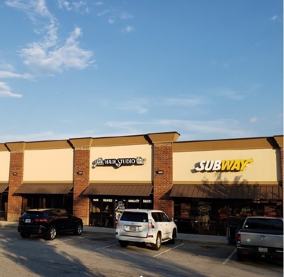
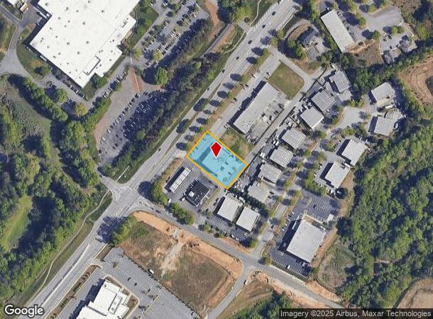
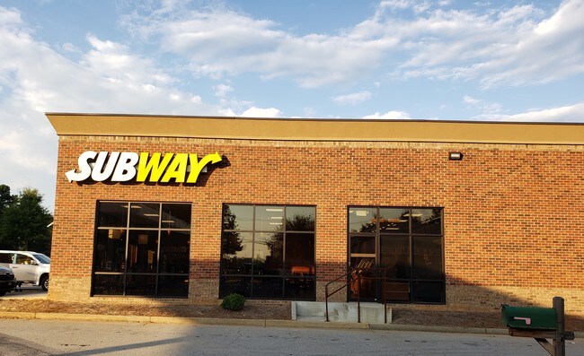
2669 Buford Hwy
Atlanta-Sandy Springs-Roswell, GA
Brickton North
7-296-154
L19 BA BRICKTON NORTH
Stripcommercialcenter
Gwinnett
X
Georgia
13135C0008G
19
2025
0.78 AC
2025
Suwanee/Buford
050105
Atlanta
8,624 SF
DEMOGRAPHICS near 2669 Buford Hwy
1 Mile
3 Mile
5 Mile
2024 Total Population
3,340
39,438
110,033
2029 Population
3,543
41,936
117,539
Pop Growth 2024-2029
+ 6.08%
+ 6.33%
+ 6.82%
Average Age
36
38
38
2024 Total Households
1,079
13,033
36,261
HH Growth 2024-2029
+ 6.30%
+ 6.51%
+ 6.99%
Median Household Inc
$65,526
$77,507
$85,674
Avg Household Size
3.10
3.00
3.00
2024 Avg HH Vehicles
2.00
2.00
2.00
Median Home Value
$378,471
$332,124
$336,382
Median Year Built
1983
2000
2002
Nearby Places
Map Layers
Map Styles
 Street
 Aerial
- Restaurants
- Banks
- Shops
- Fitness
- Groceries
PUBLIC TRANSPORTATION
AIRPORT
Hartsfield - Jackson Atlanta International
DRIVE
WALK
Distance
Hartsfield - Jackson Atlanta International
62 min
47.6 mi
SALE & LEASE HISTORY
LISTING DATE
SALE/LEASE

Sep 13, 2017
For Sale
Oct 13, 2019
For Sale
Jul 28, 2017
For Lease
Dec 27, 2016
For Lease
Dec 03, 2019
For Sale
Nearby Properties
Address
Land Use
TOTAL SIZE
Lot Size
Zoning
Address
Land Use
TOTAL SIZE
Lot Size
Zoning
285,000 SF
97.06 AC
M-I
Address
Land Use
TOTAL SIZE
Lot Size
Zoning
815,563 SF
58.80 AC
M-I
Address
Land Use
TOTAL SIZE
Lot Size
Zoning
101,632 SF
78.33 AC
M-I
Address
Land Use
TOTAL SIZE
Lot Size
Zoning
286,520 SF
21.60 AC
P
Address
Land Use
TOTAL SIZE
Lot Size
Zoning
384,000 SF
23.08 AC
BG
Address
Land Use
TOTAL SIZE
Lot Size
Zoning
213,532 SF
44.32 AC
M-I
Address
Land Use
TOTAL SIZE
Lot Size
Zoning
521,231 SF
46.16 AC
HM1
Address
Land Use
TOTAL SIZE
Lot Size
Zoning
461,700 SF
43.77 AC
C2
Address
Land Use
TOTAL SIZE
Lot Size
Zoning
144,000 SF
21.13 AC
RM
Address
Land Use
TOTAL SIZE
Lot Size
Zoning
204,436 SF
16.28 AC
BG2
Address
Land Use
TOTAL SIZE
Lot Size
Zoning
652,710 SF
40.90 AC
M1
Address
Land Use
TOTAL SIZE
Lot Size
Zoning
440,904 SF
37.84 AC
M1
Address
Land Use
TOTAL SIZE
Lot Size
Zoning
264,600 SF
10.27 AC
M1
Address
Land Use
TOTAL SIZE
Lot Size
Zoning
150,591 SF
24.39 AC
P
Address
Land Use
TOTAL SIZE
Lot Size
Zoning
641,180 SF
57.04 AC
M1
Address
Land Use
TOTAL SIZE
Lot Size
Zoning
875,180 SF
58.69 AC
C1
Address
Land Use
TOTAL SIZE
Lot Size
Zoning
573,750 SF
43.94 AC
C1
Address
Land Use
TOTAL SIZE
Lot Size
Zoning
143,000 SF
41.30 AC
M-I
Address
Land Use
TOTAL SIZE
Lot Size
Zoning
274,018 SF
25.57 AC
M1
Address
Land Use
TOTAL SIZE
Lot Size
Zoning
458,256 SF
26.39 AC
M-I
Address
Land Use
TOTAL SIZE
Lot Size
Zoning
72,304 SF
83.10 AC
R100
Address
Land Use
TOTAL SIZE
Lot Size
Zoning
261,368 SF
5.80 AC
M-I
Address
Land Use
TOTAL SIZE
Lot Size
Zoning
506,870 SF
21.60 AC
M1
Address
Land Use
TOTAL SIZE
Lot Size
Zoning
488,890 SF
59.62 AC
M1
Address
Land Use
TOTAL SIZE
Lot Size
Zoning
225,851 SF
34.35 AC
R75
Address
Land Use
TOTAL SIZE
Lot Size
Zoning
300,000 SF
23.03 AC
M-II
Address
Land Use
TOTAL SIZE
Lot Size
Zoning
445,214 SF
54.83 AC
C2
Address
Land Use
TOTAL SIZE
Lot Size
Zoning
350,084 SF
40 AC
M1
Address
Land Use
TOTAL SIZE
Lot Size
Zoning
422,933 SF
42.35 AC
M1
Address
Land Use
TOTAL SIZE
Lot Size
Zoning
94,574 SF
18.12 AC
RS100
The World's #1 Commercial Real Estate Marketplace
Connect with us
© 2026 CoStar Group
The information above has been obtained from sources believed reliable. While we do not doubt its accuracy we have not verified it and make no guarantee, warranty or representation about it. It is your responsibility to independently confirm its accuracy and completeness. Any projections, opinions, assumptions, or estimates used are for example only and do not represent the current or future performance of the property. The value of this transaction to you depends on tax and other factors which should be evaluated by your tax, financial, and legal advisors. You and your advisors should conduct a careful, independent investigation of the property to determine to your satisfaction the suitability of the property for your needs.